
Seeing What the Eye Cannot —
AI-Powered Photogrammetry
for Structural & Heritage Diagnostics
AIM3DI combines ultra-high-resolution photogrammetry, deep learning, and immersive visualization to detect surface defects in infrastructure and digitally preserve cultural heritage — across two continents.

About AIM3DI
AIM3DI (AI-Enhanced Photogrammetric 3D Modeling and its Application to Inspection of Structural and Material Surface Defects) is a three-year applied research project funded under the TAČR SIGMA programme. It brings together Czech and Korean expertise to develop an integrated system that merges photogrammetry, Reflectance Transformation Imaging (RTI), computer vision, and immersive VR environments into a single diagnostic and visualization pipeline.
The project addresses two interconnected challenges: reliable, non-invasive detection of structural defects in civil infrastructure — and scalable digital documentation of cultural heritage objects. By uniting these domains under one methodology, AIM3DI creates tools that serve bridge inspectors, heritage conservators, and the general public alike.
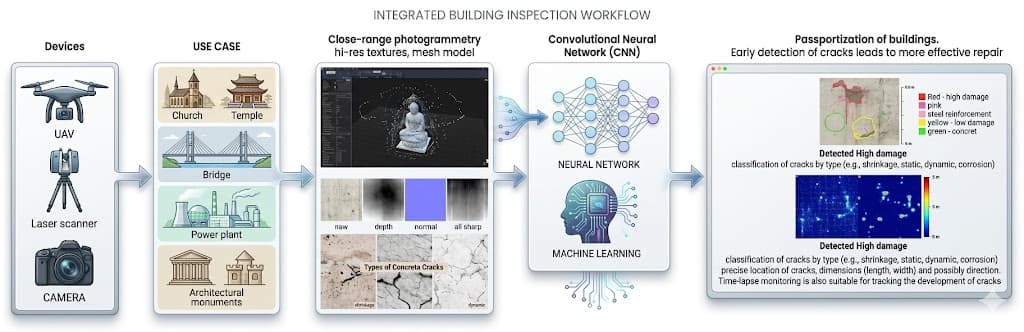
Integrated Inspection Workflow
From UAV & laser scanner data capture through CNN-based crack detection to building passportization
Our Approach
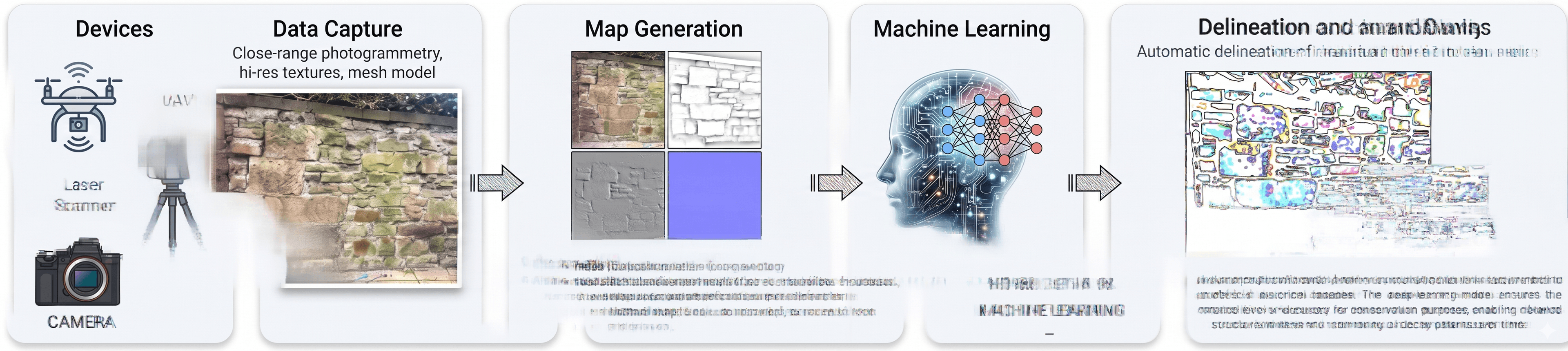
Ultra-High-Resolution Photogrammetry
Full-frame and medium-format cameras on UAVs and ground rigs capture surface data at sub-millimeter precision. Every crack, weld seam, and masonry joint is preserved in geometry and texture.
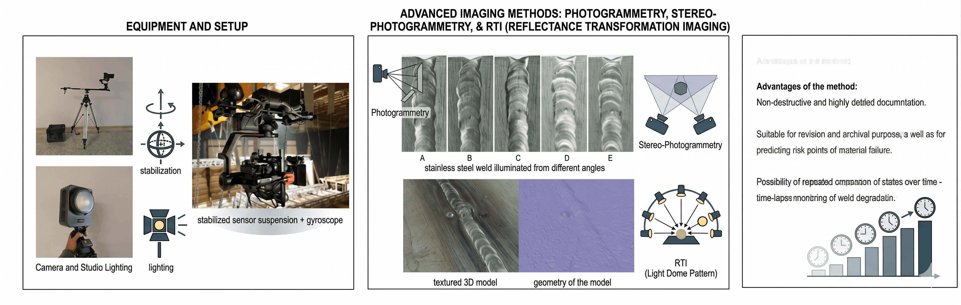
Reflectance Transformation Imaging (RTI)
Multi-angle controlled lighting reveals surface details invisible to standard photography. RTI composites are fused with photogrammetric 3D models to enrich the diagnostic layer.
AI-Powered Defect Detection
Convolutional neural networks trained on annotated datasets automatically identify cracks, porosity, weld defects, and material degradation — structured into a digital crack passport with location, severity, and type.
Immersive Metaverse Visualization
Annotated 3D models delivered through a VR-compatible platform built in Unity and Unreal Engine. Multi-user interaction, multilingual content layers, and avatar-based navigation make complex spatial data accessible.
Where It Applies
Infrastructure Inspection
Bridges · Industrial Tanks · Building Facades
Automated surface analysis replaces subjective visual assessments with repeatable, data-driven diagnostics. The system integrates into existing maintenance workflows and asset management platforms, delivering structured defect records with location, severity, and type.
Cultural Heritage Preservation
Temples · Historical Facades · Museum Artifacts
High-resolution digital surrogates capture the current state of endangered sites. RTI enrichment reveals inscriptions and surface textures invisible to the naked eye — creating a lasting digital record for conservation, research, and public access.
Education & Public Engagement
Universities · Museums · Virtual Exhibitions
The immersive platform transforms raw 3D data into interactive learning environments — bringing civil engineering, archaeology, and architecture into the metaverse. Multi-user, multilingual, and avatar-based navigation for diverse audiences.
Project Roadmap
Phase 1 — Analysis & Design
- System architecture definition
- Literature review and stakeholder consultations
- Design of experimental setups — multi-camera rigs, lighting systems, UAV calibration
- Benchmarking classical photogrammetry vs. Gaussian Splatting
- Selection of pilot sites (bridges, tanks, heritage facades)
Phase 2 — Development & Testing
- UAV and ground-based scanning campaigns in Czech Republic and Korea
- Generation of high-resolution 3D models with full texture maps
- Training of deep learning models for automated crack and defect detection
- First version of the immersive VR platform with data layers
- Multi-user synchronization prototype
Phase 3 — Validation & Deployment
- Field validation at operational sites in both countries
- Comparison of automated outputs with manual expert documentation
- Finalized metaverse gallery with multi-user avatars, trilingual interface (CZ–EN–KR)
- Final stakeholder workshop and public dissemination
- Delivery of both functional samples
Phase 1 — Analysis & Design
- System architecture definition
- Literature review and stakeholder consultations
- Design of experimental setups — multi-camera rigs, lighting systems, UAV calibration
- Benchmarking classical photogrammetry vs. Gaussian Splatting
- Selection of pilot sites (bridges, tanks, heritage facades)
Phase 2 — Development & Testing
- UAV and ground-based scanning campaigns in Czech Republic and Korea
- Generation of high-resolution 3D models with full texture maps
- Training of deep learning models for automated crack and defect detection
- First version of the immersive VR platform with data layers
- Multi-user synchronization prototype
Phase 3 — Validation & Deployment
- Field validation at operational sites in both countries
- Comparison of automated outputs with manual expert documentation
- Finalized metaverse gallery with multi-user avatars, trilingual interface (CZ–EN–KR)
- Final stakeholder workshop and public dissemination
- Delivery of both functional samples
What We Deliver
Photogrammetry & RTI Diagnostic System
A modular system for acquiring, processing, and analyzing high-resolution 3D surface data. Integrates photogrammetry, RTI, and AI-assisted feature detection into a field-ready inspection workflow for both infrastructure and heritage applications.
Metaverse Visualization Platform
An interactive VR platform for real-time exploration of annotated photogrammetric models. Supports multi-user collaboration, multilingual content, and integration of analytical overlays such as crack maps and digital reconstructions.
Research Papers & Reports
Research report on Gaussian Splatting for metaverse visualization. Two peer-reviewed scientific articles presenting methodological innovations and experimental results from Czech and Korean field campaigns.
The Consortium
Czech–Korean synergy across photogrammetry, AI diagnostics, heritage conservation, and immersive visualization.
NDN Tech s.r.o.
Specializes in photogrammetry, AI-based diagnostics, and UAV integration. Leads data acquisition, deep learning model development, and the diagnostic system workflow.
VSB – Technical University of Ostrava
Brings expertise in virtual/augmented reality, digital twin visualization, and immersive platform development. Leads the design and deployment of the metaverse environment.
Dongguk University
Long-standing research in AI, image analysis, and digital documentation of traditional Korean architecture. Provides cultural informatics expertise and heritage datasets.
SHINEST Technology
Applied experience in heritage digitization, drone-based photogrammetry, LiDAR-RGB fusion, and public-facing web platforms for national digital archives.
Czech–Korean Synergy
AIM3DI is built on a bilateral partnership that combines geographically and culturally diverse data sources, methodologies, and end-user scenarios. Czech partners contribute advanced photogrammetry, immersive visualization, and AI diagnostics. Korean partners bring heritage documentation expertise, RTI workflows, and real-world deployment in cultural institutions. Together, the consortium validates tools across both infrastructure and heritage environments — ensuring results that are robust, transferable, and globally relevant.
Why It Matters
For Industry
- Reduced inspection costs and faster defect identification
- Automated diagnostics integrated into asset management
- Serving energy providers, transport authorities, and construction firms
For Heritage
- Long-term digital preservation of endangered sites
- Scalable virtual exhibition systems
- Enhanced public access, tourism, and educational outreach
For Research
- Interdisciplinary innovation at the intersection of computer vision, photogrammetry, and immersive media
- Open data structures and reproducible workflows
- Models for future Horizon Europe and bilateral projects
For Society
- Improved safety of public infrastructure
- Wider access to cultural assets through immersive digital experiences
- Inclusive design — accessible to elderly and mobility-limited audiences